ConDev awarded a Transformative Solutions Grant to Sharing the Land (STL) and USAID recently funded the development of a Research-To-Action Plan on this program. This Action Plan was produced by the Population Reference Bureau under the Research Technical Assistance Center (RTAC).
DRC-STL_Research-to-Action Plan_FINAL
Sharing the Land AgriLife Today Story (Dec 2020)
Project Summary
The STL program is an initiative under the Integrated Research Institute (IRI) at the Christian Bilingual University of Congo (UCBC ) based in Beni, North Kivu, Democratic Republic of the Congo (DRC). The vision of STL is to promote peace by facilitating transparent, fair, and equitable land ownership practices in eastern DRC. STL’s mission is to use research, technology, community engagement, and public sector activism to produce a sustainable, dynamic, effective, transparent land registry system to be implemented in North Kivu to prevent land conflict.
Sharing the Land uses GIS and GPS technologies coupled with community organizing principles in order to mobilize all community stakeholders to address land conflict, improve urban planning and to develop a transparent and effective land management system, which promotes a continuum of land rights for all land owners, tenants and squatters in eastern DRC. This initiative, led by local students at the Christian Bilingual University of Congo (UCBC), employs an innovative approach to reducing conflict over land use and ownership by aggregating, mapping, and publicizing land ownership claims in the North Kivu region of the Democratic Republic of the Congo (DRC).

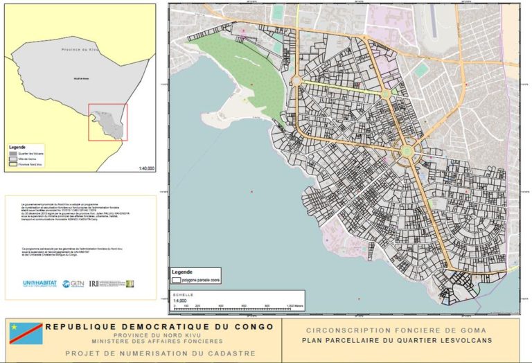
Land Ownership Map – Les Volcans Neighborhood, Goma, North Kivu, DR Congo. Sharing the Land.
STL’s work was successfully piloted in the city of Beni and has since expanded to the city of Goma in North Kivu, DRC. STL became the first of ConDev’s Transformative Solutions projects to surpass 1,000,000 beneficiaries reached. STL was featured in USAID’s Impact Blog, which applauded the group’s success in promoting peace by facilitating transparent, fair, and equitable land ownership practices in eastern Congo. These efforts include publishing a digital map of Beni online with landmarks, points of interest, rivers, administrative boundaries, road names and their current condition, along with mapping all six cells of the Masini Quarter. The map also lists all land claims and conflict data collected from household surveys and government records.
The team was also selected to present at USAID’s Innovation Marketplace as part of TechCon 2016 at MIT in November 2016. In December 2016, IRI/STL completed a land ownership map of Goma’s Les Volcans neighborhood in Goma, DRC. Keep up with their latest progress on Twitter!